
My plan had been to make a quick exit from the airport, and to be in my car by around 9:30pm. I had booked a room at the Red Roof Inn in Parsippany through Hotels.com, having picked that town because it was roughly only half an hour's drive from the airport, and just far enough out of town to (hopefully) not have traffic snarls in the morning. Driving away by 9:30 should put me at the hotel around 10:00, and after a shower, perhaps a feed, and some contact with home, I could get a good night's sleep and be off again early in the morning.
Well that was the plan, but it was already after 9:40 as I walked down the escalator from P3 to the Avis office. Somehow in my previous travels, Avis gave me "Preferred Customer" status - not sure why, but I'm guessing everyone who uses them more than a given number of times becomes a Preferred Customer. So normally with that I could simply find my name on a display screen, which would tell me where my car was parked, and I could bypass the counter and go straight to it. However, because I was going to be crossing the border into Canada, I had to notify Avis at the desk before picking up my car. While I was there, I asked the not-too-friendly assistant to activate the EZ Pass device on the windscreen, which would enable me to drive straight through any tollways I may encounter ( my trip research showed there would be a few ) and the charge would automatically go to Avis and then to my credit card.
With all that done I headed out to the car park and found my Toyota Corolla waiting patiently for me. Avis boasts a 100% smoke free fleet, so after loading my carry on bag and laptop into the back seat, I leaned against the back of the car and had a long awaited cigarette while I texted home to let everyone know I'd arrived safely. It was 10:07 when I drove out of the Avis car park - an hour since touchdown, and I was running about forty minutes behind my plan.
I had researched the driving part of this trip fairly extensively before leaving home. Google Maps gave me terrific driving directions on what looked like a pretty complex system of Expressways, Parkways, State Highways, Interstate Highways and Tollways. Looking at the map, I was going to be driving into a bowl of spaghetti, and one wrong or missed turn could put me many miles away from where I wanted to be by the time I realised it. It was now well and truely night time, it was raining, and I was really glad I only had a short distance to cover. Adding to the challenge was the fact that it had been nine years since I last drove left-hand-drive, so I needed to be on my toes. Prior to leaving home I had printed off the directions from Google Maps for every stage of the drive to Canada, and so now I copied the directions to Parsippany onto the back of my left hand, so I could check as I drove. Coming out of the airport I followed the signs to I78 - Interstate 78 - then took up my position in the lane for I78 West. From there I had to find Exit 48 and merge with NJ24 West, then merge onto the I287 North. A few miles further I had to spot I80 East, with signs to New York, and then take the exit for Whippany and Lake Hiawatha. A left and a right put me on US 46, and there I found the Red Roof Inn. Clockwork!
Time Since Leaving Home: 29hrs 10mins.
It was about 10:40pm when I walked into the lobby at the Red Roof Inn. The receptionist on duty that night was a rather large African-American lady of about forty, and while not unpleasant, she certainly had a cheer deficit as she looked up my reservation and asked for photo ID in a very monotone voice. In similar tone she asked for my vehicle licence plate number, so I had to go outside to check and report back. Moments later she handed me my key-card without a smile and bade me goodnight. The hotel was considerably bigger than I realised, despite having looked at aerial images of it on Google. The rain had stopped by now, and I drove around the pretty full car park to find a stairwell that led to my room on the second level, luckily with a parking spot not far from it. I took my baggage straight in, and to my huge disappointment I found .......no coffee maker!!
It was about 10:40pm when I walked into the lobby at the Red Roof Inn. The receptionist on duty that night was a rather large African-American lady of about forty, and while not unpleasant, she certainly had a cheer deficit as she looked up my reservation and asked for photo ID in a very monotone voice. In similar tone she asked for my vehicle licence plate number, so I had to go outside to check and report back. Moments later she handed me my key-card without a smile and bade me goodnight. The hotel was considerably bigger than I realised, despite having looked at aerial images of it on Google. The rain had stopped by now, and I drove around the pretty full car park to find a stairwell that led to my room on the second level, luckily with a parking spot not far from it. I took my baggage straight in, and to my huge disappointment I found .......no coffee maker!!
Now this may seem trivial to some readers but one of the criteria I use when choosing a hotel room is that there must be coffee in the room. I like my coffee, and I like it to be available when I want it, especially when I'm paying. The listing on Hotels.com clearly said that my room had complimentary coffee/tea maker, and at this point I was really looking forward to a coffee. Needless to say, I was back in reception in minutes to have a moan. By now there was a younger African-American male at the desk, and the lady I had seen earlier was on the customer side, presumably having a break. The young man looked up my room number and told me that it was a standard room, and standard rooms don't have coffee makers. "But there is coffee available 24 hours a day in the lobby, Sir". I didn't take up the fight. It was now some thirty hours since I left home, and all I wanted to do was have a coffee, relax, contact my family, have a shower, and get some sleep. I took a coffee from the lobby and went back to my room.
 |
| My reservation clearly states the room has a coffee/tea maker. GRRR |
Apart from the pet-hate coffee issue, the room itself was fine, and for just AU$75 it gave me what I needed: a shower, a bed, and Wi-Fi in the room so that I could connect with my family on Skype at no cost. I was only there for one night, so it was almost perfect. I only had brief connectivity with home that night because in Australia it was the middle of the next day, and everyone was at work or school. I had a very welcome shower, but couldn't be bothered going out in the dark to get something to eat, so I went to bed.
After a reasonable night's sleep I was up around 7:00am New Jersey time and feeling good. I went to the lobby to claim my entitlement of coffee ( I took 2 cups to save one trip ) and proceeded to connect up to home via Skype for a video chat. It was nice to see everyone's faces again, even though it was really less than two days since I saw them. I think it's not just the time that affects you, it's also the realisation of just how far away you are that has a huge impact. I had planned to be up about an hour earlier and be on the road soon after sunrise, but it didn't quite turn out that way. I spent a bit longer than I intended talking to home, and so it was 8:30 by the time I was ready to move on. I packed my stuff into the car, left the room almost as I found it, and drove around to reception to hand back my key.
 |
| The Red Roof Inn, Parsippany, New Jersey, USA. The door in the middle of the picture is the reception and lobby entrance. There's roughly as much again of this hotel out the back, which is where my room was. |
The morning receptionist was another large African-American lady, but I think this girl had the other one's share of cheer. As soon as I walked in she greeted me with a loud and happy "Good morning!" and when I handed her my key she said, quite loudly, "Thank you Darlin' - you have yourself a great day now. Bye bye!" - in what sounded more like a southern states accent than New Jersey. So I left feeling a bit better about the place now, and a little excited about the day ahead. Time Since Leaving Home: 39hrs.
Getting out of the Red Roof Inn and heading back towards I80 West was a little bit different. You can only turn right onto US46 and of course I needed to go left. To do this, I couldn't just go to the next lights and do a U-Turn, I had to turn right at the lights and do a loop that put me back at the lights at right angles to US46. From this point I could then turn left to head back up to I80W
 |
| The way back to I80W - Google Maps is a marvellous thing! |
The last time I was in the USA was 2004, and I'd never heard of Google Maps. Prior to this trip, however, I found it an invaluable planning tool, and I used Street View extensively to gain a more real-life impression of what to look for along the way. That generated a strange sort of déjà-vu effect from time to time. Finding my way through the loop and back to Interstate 80 West was no trouble, and I found I had less difficulty adjusting to the left hand drive aspect than I thought I would. I'd spent several weeks driving on the right side of the road in 2004, in France, Canada, and the USA, so I figured it must be like riding a bike.
The I80 West was pretty much as I'd pictured it ( with a little help from Google ), but there was a bit more traffic than I was expecting. And it was fast moving. I was paying strict attention to the speed limit, and the Corolla's Cruise Control made it easy to stay at the right speed. The only problem then was that I was the slowest vehicle on the road, and at times it was a little intimidating when I looked in the rear vision mirror to see four, sometimes five lanes of cars, buses, vans and trucks charging towards me, then swarming around me like menacing wasps, and disappearing ahead of me before the next wave came up behind. Or perhaps it was because I'd only had two cups of coffee at that point.
My journey from Newark to Canada would take me across the Appalachian Mountains and three states before crossing the mighty Saint Lawrence River to enter Ontario. From the I80 West I had to merge onto the I380 North, and then the I81 North which would take me all the way up to Canada. I planned to have two stops before Canada, spaced about two hours apart, and a fuel stop close to the border so that I could make the most of the cheaper fuel prices in the US. Quite some time before I left home I already knew my way to two McDonalds restaurants that would be my food stops, and I knew I could buy fuel at Watertown, NY. I cruised the I80 in a very orderly fashion, and crossed the Delaware River to leave New Jersey and enter Pennsylvania at the Delaware Water Gap. The Gap was created by the Delaware literally cutting through a large ridge of the Appalachian mountains over millions of years. The area is quite scenic, and is a major recreation area used for activities such as canoeing, swimming, hiking and fishing. I was tempted to stop and look around, but I was already running late, and my Aunty was waiting for me, so I pressed on. Maybe on the way back next week.
Not far from the Delaware is Stroudsburg, and a few miles beyond that I merged right to take the I380 North. At this point the traffic, which had been fairly heavy, seemed to all but disappear, as most people were heading west and only a few of us heading north. Can't say I was disappointed! About 24 miles further up I left the I380 and joined the I81 North, and as that was the last road I had to find, it was a good time to have a break. I'd been driving just on two hours when I pulled into McDonalds on the corner of Scranton-Carbondale Hwy and Ravine St, in Scranton, Pennsylvania..
I'm no McDonald's freak by any means, but generally I don't mind their food, their coffee is usually good, and there's a reasonable consistency in the quality of food and service world wide. This makes it a very convenient food stop when travelling to any sort of schedule, and of course in America, there's no shortage of them. I was able to locate McDonalds restaurants along my way from home, and chose them strategically according to their proximity to the highways I was travelling on. There's more than one McDonalds in most American towns of any substance, and Scranton has five within about a two mile radius. I chose to stop at this one because it was a simple right turn off I81, left at the first set of lights, and immediately left again into their driveway. To get back onto I81 was even simpler, turning right out of the carpark onto the main road, then right again back onto the highway. The service here was very friendly and fast, and I sat in my car with the door open and my legs stretched out, watching the world go by with my McGriddle and coffee. I had seen a strange looking concrete truck somewhere along the way, which looked back to front, so when one appeared at the lights next to where I was sitting, I seized the opportunity for a snap shot:

With a short break from the road, my food and caffeine levels topped up, I was soon ready to get back on the I81 and continue northwards. The weather had been overcast with a light drizzle when I first left Parsippany, but by now there was only patchy cloud and no rain. The road climbed out of Scranton as my journey progressed through a series of small hills and valleys. The highway was a good dual carriageway all the way, with long, sweeping curves around the hillsides, occasionally peering over cute little towns and villages nestled in valleys - often compelling a closer look, if only there was more time.

My next pitstop was at Syracuse North, a little over two hours from Scranton, and 90 miles into New York State. With the pleasant scenery and a little radio entertainment, it wasn't long before the almost empty highway started to accumulate more and more traffic, and the rolling hills, elm forests and green pastures gave way to the housing estates, shopping centres and other urbanisms of the southern end of the city. Syracuse is large and busy city with a metropolitan population of well over 600,000, and is the economic and educational centre of Central New York State. Its name is derived from Siracusa, in Sicily. The I81 cuts through the middle of the city, almost in a straight line, bending left to exit on the northwest edge. Once again I found myself under attack from fast moving cars and trucks as I seemed to be the only observer of the speed limits, but the highway was still an easy passage through town. I found the exit for Mattydale where I needed to leave the 81, turn left into Brewerton Rd, and find my lunch stop about a mile up on my right. Once again my Google study paid off.
Here I was served by another large, loud, very buoyant African-American lady who I thought might have been the sister of the one I'd left behind at the Red Roof Inn that morning. She was delightful, and seemed to enjoy my Australian accent. Despite my late start to the day I was happy with the way I was travelling. The roads had been good, and even though I had seen many areas with road works along the way, the only slow-down involved was a reduced speed limit, usually from 65 to 55 or 45 mph, with double penalties applicable. As I ate my Big Mac I knew that I was now only an hour and a half from the Canadian border, plus whatever time it would take to make a fuel stop at Watertown, about an hour away. Turning right out of McDonald's put me back on Brewerton Rd, and another right then a left soon had me back in Cruise Control on the 81. The remainder of this road trip I had driven before. In 2004 we crossed into New York State from Niagara Falls, Ontario, and drove through Rochester and onto the I81 at Syracuse, to return to Canada when we were staying near my Uncle and Aunty's place. Not that that leant any familiarity to this stretch of road - in 2004 it was well and truely dark by the time we reached Syracuse, so we didn't see anything along the way.
 |
| Pennsylvania welcomed me! |
 |
| My Corolla with the internationally unmistakable facade of McDonald's behind. |
 |
| One of the things I love about travel: there's always going to be something you don't see every day, even in a McDonald's carpark! |

 |
| Tucked away in a valley, little towns like this are always worth a look - maybe next time.... |
My next pitstop was at Syracuse North, a little over two hours from Scranton, and 90 miles into New York State. With the pleasant scenery and a little radio entertainment, it wasn't long before the almost empty highway started to accumulate more and more traffic, and the rolling hills, elm forests and green pastures gave way to the housing estates, shopping centres and other urbanisms of the southern end of the city. Syracuse is large and busy city with a metropolitan population of well over 600,000, and is the economic and educational centre of Central New York State. Its name is derived from Siracusa, in Sicily. The I81 cuts through the middle of the city, almost in a straight line, bending left to exit on the northwest edge. Once again I found myself under attack from fast moving cars and trucks as I seemed to be the only observer of the speed limits, but the highway was still an easy passage through town. I found the exit for Mattydale where I needed to leave the 81, turn left into Brewerton Rd, and find my lunch stop about a mile up on my right. Once again my Google study paid off.
 |
| As recognisable as the American Flag itself, McDonald's in Syracuse North. |
Now clear of the Appalachians and the suburban sprawl of Syracuse, the landscape was wide open, sweeping plains, largley pastoral undulating hills and broad valleys. Along the way I'd seen many signs saying "Food Exit" or "Fuel Exit", and in most cases the food or fuel outlet had been visible from the highway. Approaching Watertown there was a similar sign, so I turned off and followed my nose towards the town. It was actually two and a half miles to the Mobil Gas Station and for a moment I thought I might have missed it. I filled my car for US$30, and considering I was now only about half an hour from the border I felt that was a pretty cheap ride. I went in and paid for my fuel and bought a packet of Marlboro 100's - in a genuine Marlboro brand packet!
Retracing my steps I returned to the 81 for the last few miles of this highway. Less than half an hour later I came to a toll bridge, and to my disappointment there was no EZ-Pass lane, so I had to stop and fumble with the unfamilair US coinage in my pocket to make my $2.75 payment. This was the first section of the Thousand Islands Bridge, made up of five sections which cross the St Lawrence River in the Thousand Islands Region. I started to feel quietly excited now as I knew I was really close to Canada, and indeed just five minutes later I was pulling up at the Canadian Border Control. The officer here was very friendly, and asked me the usual questions about what brings me to Canada, where had I come from and so on. After stamping my passport he handed it back to me, welcomed me to Canada, and said to enjoy my stay.
 |
| 3 minutes from Canada, at the Border Control |
 |
| YES!! I was in Canada! |
Time Since Leaving Home: 46hrs 18mins
The last leg of my road trip was also the shortest, but even though I was now barely an hour from Nicholson's Point I felt that entering Canada was a milestone worthy of a coffee break. Plus I needed a toilet break, and to send a Happy Birthday message to my daughter, as I realised that in Australia it was now the morning of her birthday. My plan originally was to drive to Gananoque, about fifteen minutes from the border, where I had previously scouted out a Tim Horton's Restaurant. But as I was having trouble sending my birthday message and I knew that just around the corner from the Welcome To Ontario sign was the Thousand Islands Skydeck, I decided there was no time like the present.
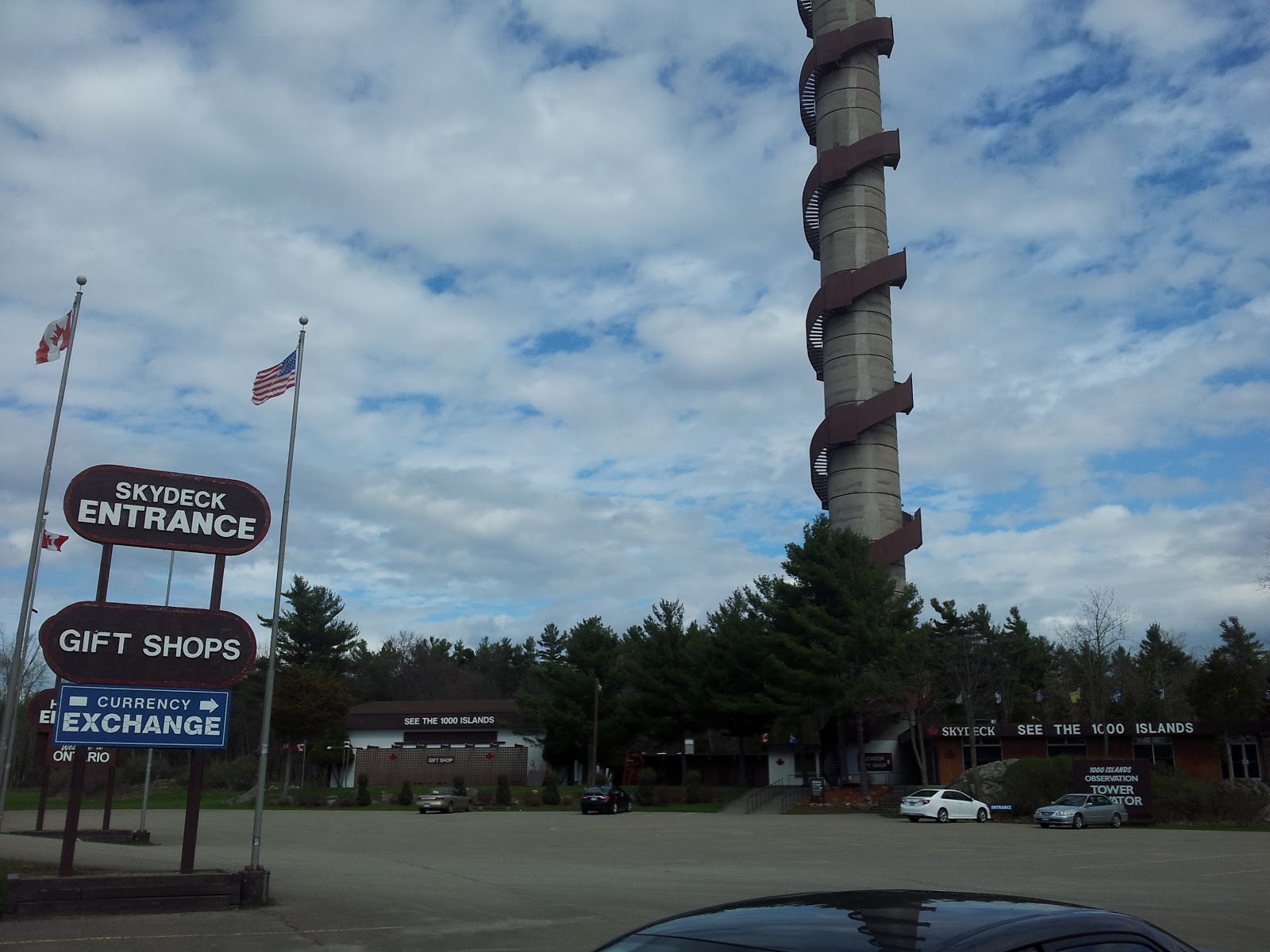 |
| The Skydeck Tower at Thousand Islands - 400 feet from the ground |
Inside the souvenir shop I found new owners of just two weeks, and self-serve brewed coffee for $1. I talked with Heidi and her husband ( didn't get his name ) for a few minutes about the poor phone reception and the fact that I had been here with my family nine years ago. I didn't have any Canadian money yet, but Heidi was quite happy to accept an American Dollar for my coffee. I didn't succeed in sending the message to my daughter, so I moved on before long, resolving to try again from Kingston.
As I now wasn't going to Gananoque my route from here was even simpler. The road I was on went straight to an interchange where I could slip onto Highway 401. The 401, officially called the MacDonald-Cartier Freeway, runs across the southern edge of the province of Ontario from the Quebec border in the east to Windsor in the west, adjascent to Detroit, Michigan, a distance of about 820 kilometres. Today I was only going to use 45 of those kilometres, turning off at Sir John A MacDonald Boulevard to work my way through Kingston from the north, and exit on the Kingston-Bath Road in the West. Kingston is a small city on the north side of Lake Ontario, midway between Montreal and Toronto. The city has a metropolitan population of around 160,000, and was the first capital of the Province of Canada in 1841. Although it was approaching 5pm, the traffic was only moderate and flowing well, and in about fifteen minutes I was on Bath Road, and back in familiar territory. From here, I knew my way quite well. Bath Rd runs along the edge of Lake Ontario from Kingston through Bath and out to Bloomfield on the Prince Edward County Peninsula, to just outside Trenton, nearly back to the 401. It is also known as Kington 33, and from Amherstview to Trenton it is also called Loyalist Parkway. Just outside Amherstview was my turn off to the left, heading towards the lake and Nicholson's Point. This quiet, low density residential area is only populated on one side of the road, the other side being nature reserve. I wandered slowly down my Aunty's street among the cedar and hickory trees, and turned into her driveway at 5:05 pm.
Time Since Leaving Home: 47hrs 35mins

I hope you've enjoyed reading this page, and if you have, please feel free to use the buttons below to share it through your favorite Social Media. If you didn't enjoy it, I'd love to know why - constructive criticism is always welcome, so please feel free to comment.
No comments:
Post a Comment